


Fintry's Oldest House.
Rediscovering a lost village!

Perhaps the most consequential point for Scotland’s countryside was the late 18th century: The Age of Improvement. The lowlands were cleared of small scale farmers (a peaceful process) who all started work in the new factories. Medieval rig and furrow was ploughed up and replaced with square fields, new crops, new ploughs and a 300% increase in agricultural output….astonishing.
Hill of Balgair
My story today concerns The Hill of Balgair. The two maps below are from the National Map Library of Scotland’s website. The left map show’s Roy’s mid-18th century map while the one on the right is from c 1850 (the 1st edition Ordnance Survey).
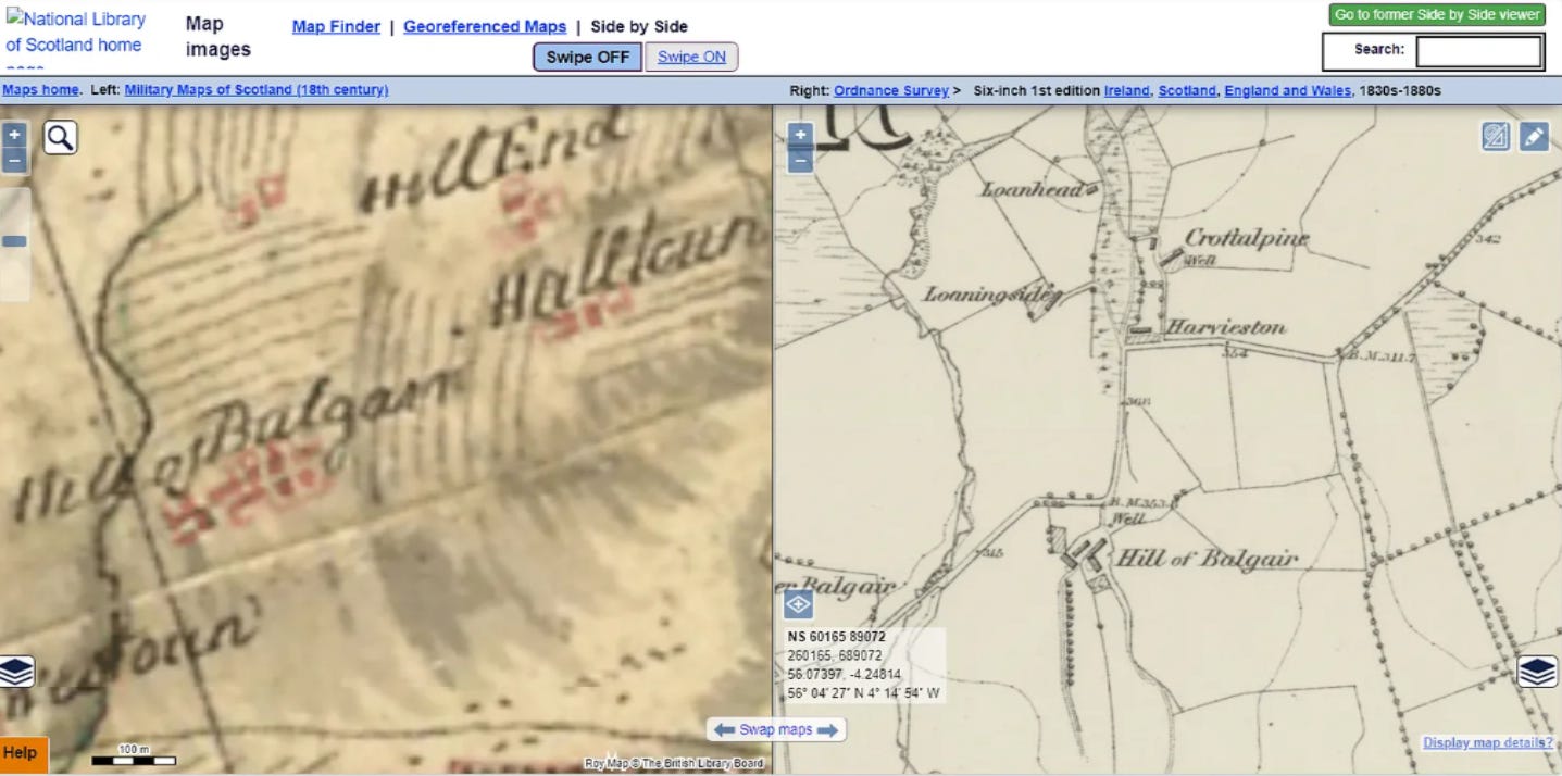
On Roy’s map Hill of Balgair (HoB), which was once bigger than Balfron shows a main street and several side streets. Importantly Roy never mapped all the buildings only the important ones, so the village will have been bigger. To add further confusion its likely that the farm ‘Hill of Balgair’ on the right is not the village, just that the name moved. But quite where was it?
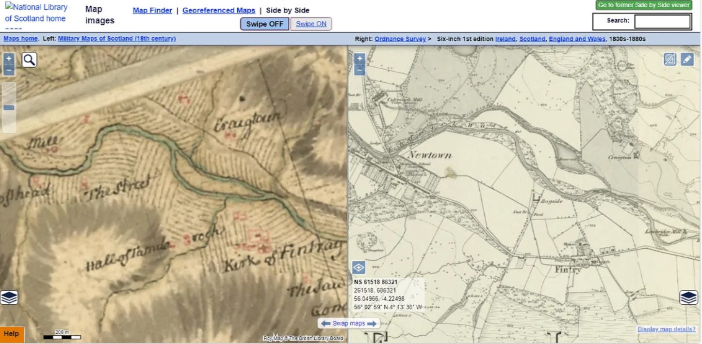
But before we get to that lets have a quick look at one of these new factory towns just down the road known initially as The Street and then Newtown and then finally Fintry. You can also see from both of these maps how the rig and furrow (the wee sets of parallel lines) were replaced with square fields. This made both ownership and ploughing easier!
The Royal Commission on Ancient and Historic Monuments of Scotland.
But to return to exactly where was HoB …enter stage left our heroes, the former RCAHMS now swallowed whole by Historic Environment Scotland. This grand old dame of Scottish archaeology set out to map Scotland’s archaeology and produced a series of exceptional volumes , Stirlingshire’s two were produced in 1963 with the work having been done in the 50s. They ran out of puff in the 90s and the last volume ever produced was for the Don Valley round Inverurie. Beyond Inverurie remains terra incognita…..but that is another story.
The men from the Commission walked Fintry’s fields on the 9th October 1952….(presumably cold damp and muddy) and found the following!
Old Farms, Balgair.
These remains are situated, at a height of 320ft OD, on gently sloping ground 570 yds NE of Hill of Balgair farmhouse and a quarter of a mile E of Croftalpine farmhouse. They occupy a field of rough pasture, and consist of a group of rectangular foundations and irregular courts and enclosures (fig. 168, plan). The remains are bounded on the NW by a stretch of the bank that borders the modern road; this measures 200ft in length and probably incorporates a sector of the original boundary of the farms. A low bank, which measures about 8ft in width, springs from the SW end of the NW boundary and runs SSE for a distance of 300ft before turning SW and running for a further distance of 70ft, beyond which it is lost in a cultivated field. A similar low bank runs SE from the NE end of the NW boundary on a somewhat sinuous course for a distance of 200ft. After a break 25ft in breadth it continues generally southwards for a further 125ft, and then gives way to a scarp which runs thence SW for 330ft before dying out at a point only 60ft SSW of the end of the W boundary-bank.
Within the irregular area thus outlined are the remains of houses and farm-buildings. The most conspicuous of these is the one marked A on the plan; it consists of the ruins of a stone wall, measuring 3ft 6in in width and now standing to a maximum height of 2ft, which forms two contiguous rectangles. Each measures 24ft in length by 12ft in breadth and each has a narrow gap in both its long sides. The long axis of this structure runs from NNW to SSE. At a distance of some 13 yds to the W of A there is another rectangular structure (B); part of this is defined by the ruins of a wall measuring 3ft 6in in width and part by a low grass-grown bank. This structure measures internally about 45ft in length by 12ft in breadth, and its long axis runs from N to S. A narrow gap pierces the E side at about its middle point.
A third rectangular foundation (C) lies close to the SSE end of A; it measures internally 56ft in length from NE to SW by 15ft transversely within a ruined stone wall 3ft 6in in thickness. This structure is not so well preserved as are A and B, and it is impossible to distinguish the position of an entrance. A rectangular structure defined by a low, narrow grassy bank adjoins the SW. end of C; it contains two compartments, the larger of which measure 20ft in length by 10ft in breadth and the smaller 10ft in breadth by 8ft in length. Close to the SE end of C, but not quite contiguous with it, are the scanty remains of another small straight-sided structure the walls of which measures 2ft in thickness.
The rectangular foundation C may represent a barn, as it forms a substantial part of the NW side of a square court or yard (D) which measures about 100ft along each axis. This court is bounded on the SW by a low grass-grown bank about 7ft in width, and on the SE by a stretch of the scarp that forms the SE border of the site. On the NE there is a scarp about 3ft in depth which falls to boggy ground outside the court. The remaining major feature is an irregular enclosure (E) which lies N of the principal rectangular foundation A. This enclosure is bounded by a grass-grown stony bank which stands to a maximum height of 2ft and is spread to a maximum width of 9ft. It measures 110ft in length from NE to SW by a maximum of 90ft transversely. There is an entrance 12ft in width in the E, and a gap 33ft in width in the S which lies close to ruin A.
Numerous slight and amorphous remains of banks lie in the E sector of the enclosed area; a shallow depression 45ft in length and 10ft in width which lies in the N part of the enclosure may represent the remains of a road.
It is probable that these structures were part of the vanished hamlet of the Hill of Balgair, which was once a larger place than Balfron and was occupied by cottars and weavers and possessed a public house and shops (1). Some of the carved stones now seen in the neighbourhood (Nos. 447 and 448) may well have come from this hamlet
They even produced a wee plan……


This would then be the target of our research. But the remains are Scheduled and so we proposed to dig round the field and to look for ploughed out remains of this lost village. So I spoke to the Fintry Museum Trust (a great wee place in the Sports Centre which serves a very tasty coffee, bun and lunch) who spoke to both the tenant and the landowner and we agreed a plan. We’d dig a series of 1m by 1m test-pits, these would be aimed at finding spreads of pottery from rubbish dumped from the village.
The 19th September 2024….9:55 am
And so over 70 years from its re-discovery archaeologists began to look again for HoB. It was a lovely day and as we began to dig the young lambs watched and waited…..what were we doing?
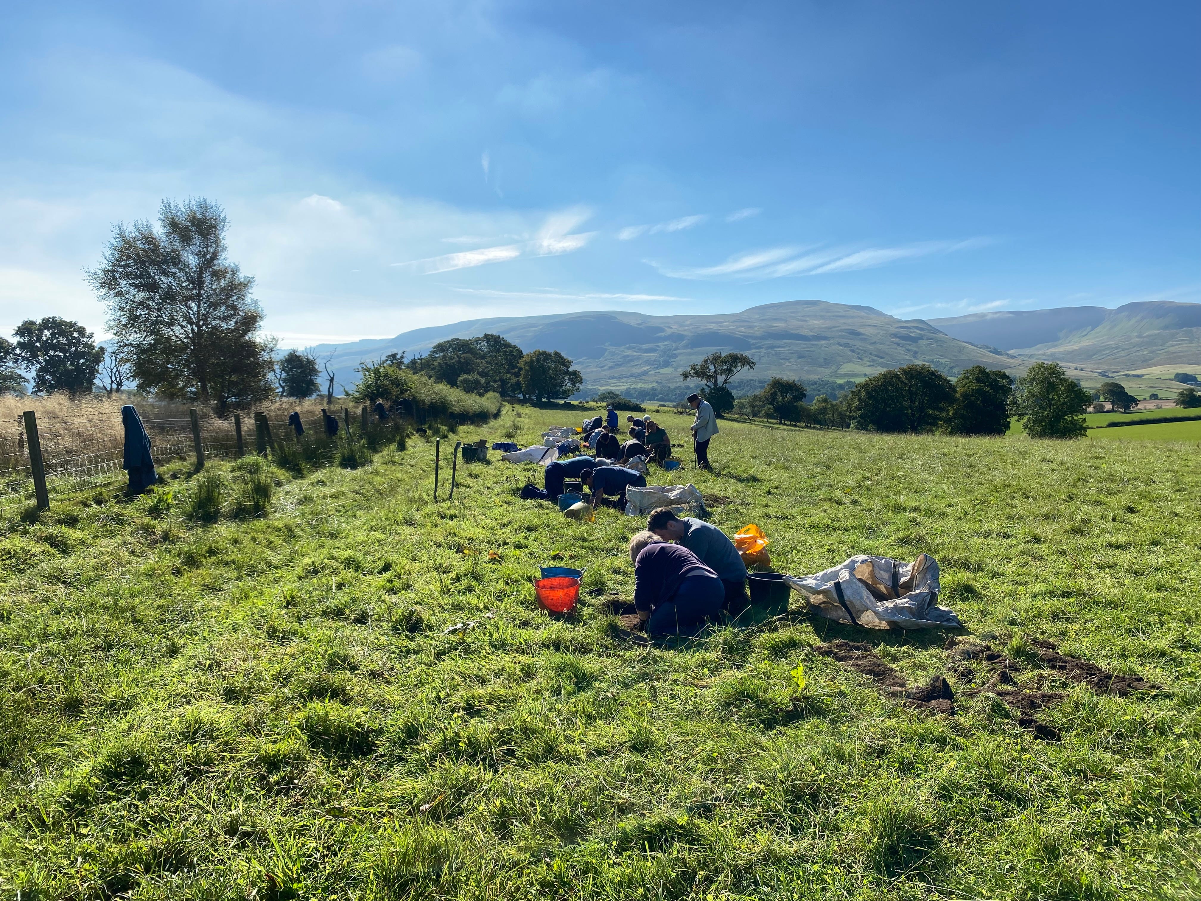
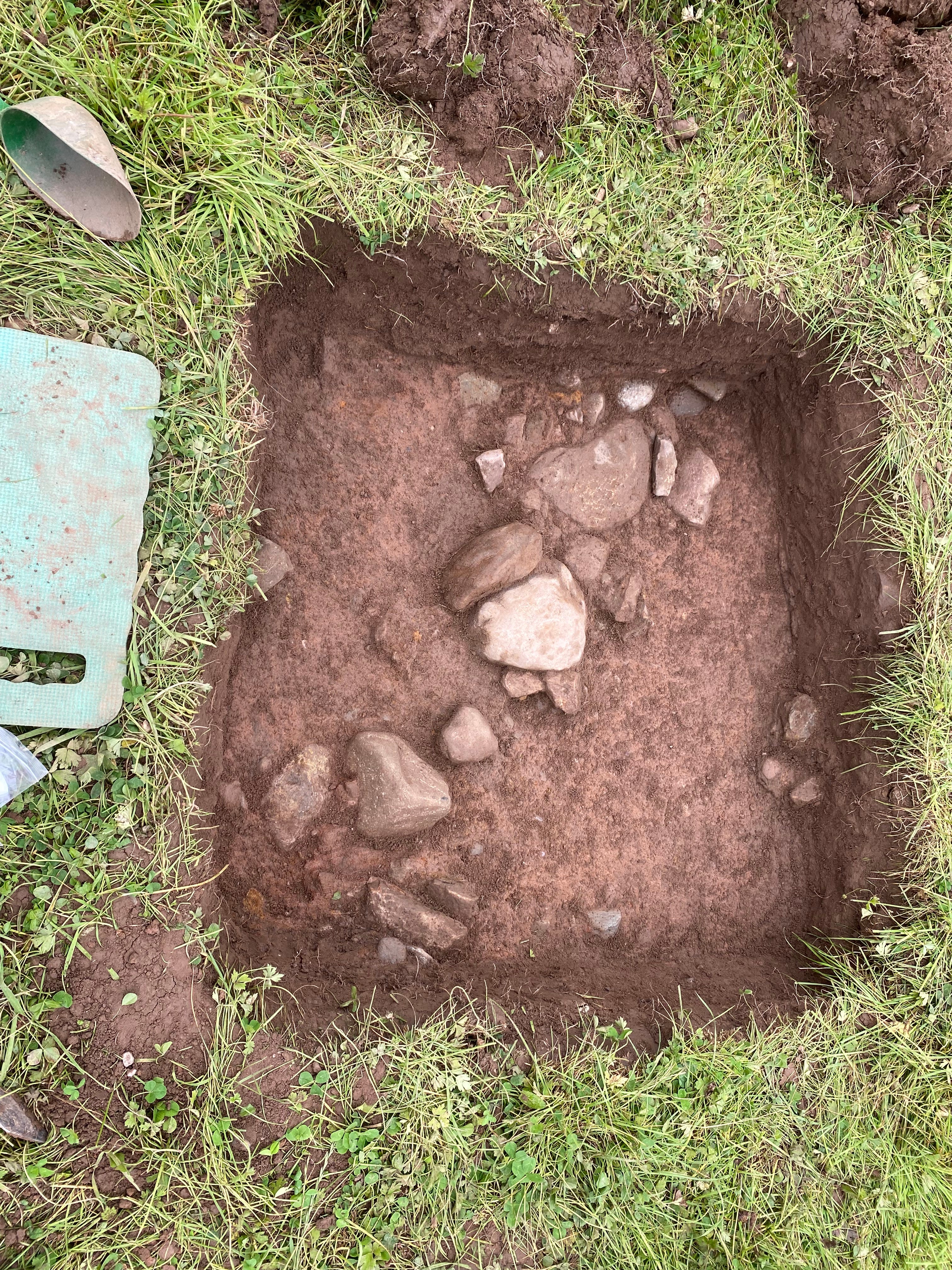
Now as Mike Tyson said once …everyone’s got a plan till you’re punched in the face. And so it was with us….though of course it was a metaphorical punch and really more a pleasant tickle! After 18 test-pits there was not even a hint of medieval pottery but and its a very, very big but we found several other things all a tad more important in my humble opinion, but as you’ll remember I’m a prehistorian.
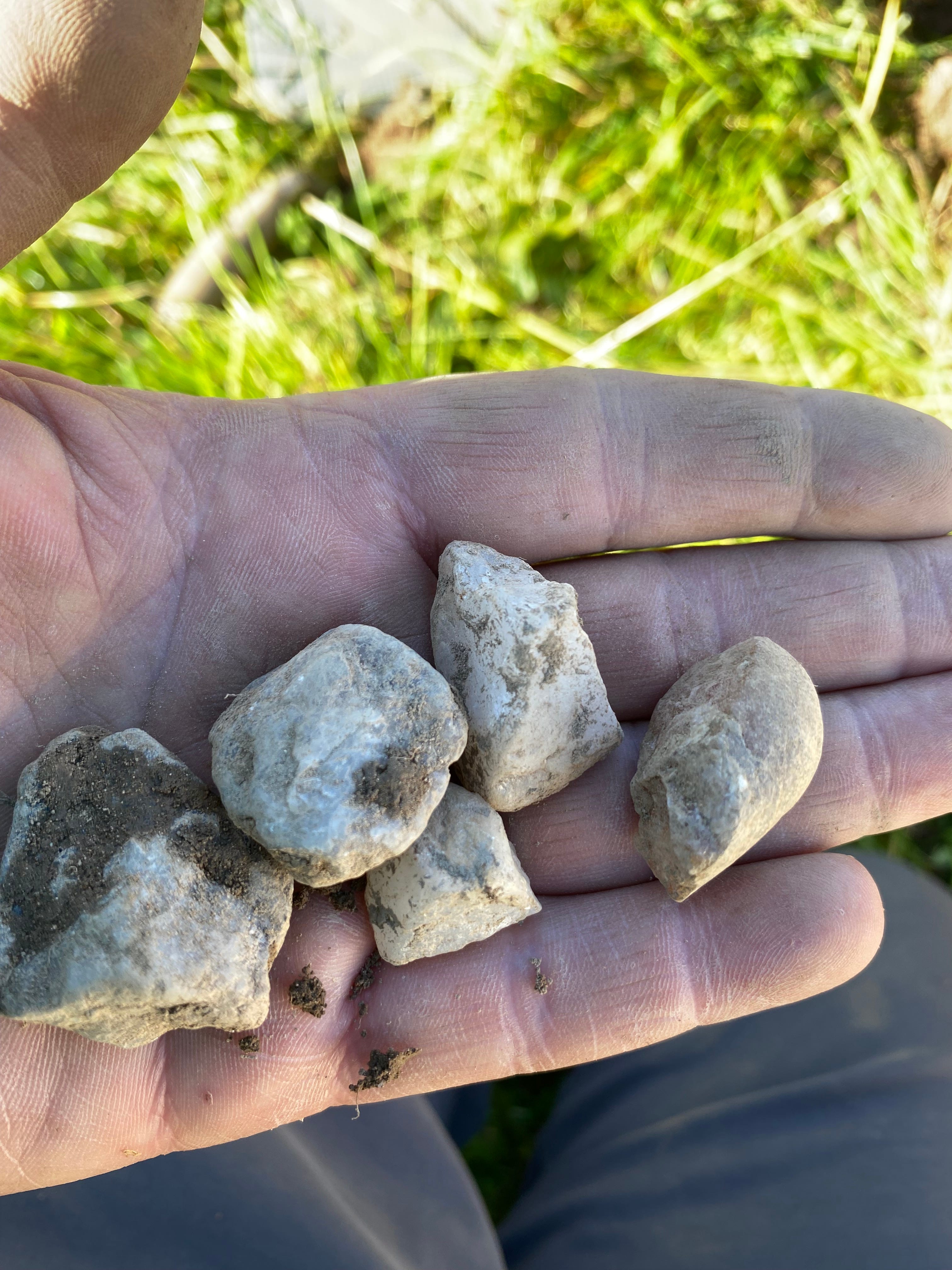
Lots and lots and lots of struck quartz in a clear grouping ie a prehistoric settlement site, which likely dates to c 1000-700 BC. There was even a hint of Neolithic and for the lithic geeks out there quartz outnumber chert/flint by c 100-1! Something only we achieve…..we really are the best in Scotland.
But it gets even better….as we kept digging we also found foundations. The field here is a south facing wee terrace, an ideal place to live. We think we found foundations of up to 3 roundhouses (we need to confirm though), perhaps 3500 years old. Wow!
What else? ….honestly what is it with you people….are you never satisfied?
Now I know my audience so if all of this was not enough one of the volunteers Tim started looking on his phone at the lidar of the next field and spotted an enormous enclosure…….was this a lost hillfort?

Double wow…..but that’s next year’s work! And if you want to get involved let me know…all are welcome …..even medievalists.
Have a question? Get in contact!
Conclusions….
No firm conclusions yet….lots of things we didn’t expect and no trace of the Hill of Balgair yet…..but gosh isn’t archaeology simply the most fun you can have with your trousers on!
Help support Stirling Archaeology continue to provide great local content on a regular basis by becoming a paid subscriber for only £3.50 a month or £20 a year.
This made me laugh, "What else? ….honestly what is it with you people….are you never satisfied?" A very interesting find, thanks for sharing and to all those who help out.
Absolutely fascinating Murray. Thank you.